 CERESChemical Emergency Response E-Service
Product sheet
You go toward it. We make sure you can see it.
A hazmat call is a chain of decisions made in minutes, on a placard, a wind sock and a phone that keeps ringing. CERES is built with the people who make those decisions, so that the zone, the crew and the neighborhood are in front of them while there is still time to act. It runs in any browser on the apparatus laptop, the tablet and the phone, with nothing to install.
- The zone on the map before the first unit is on scene, with the people inside it counted
- Every crew member on the board, every PAR answered, every minute logged without a clipboard
- The same picture on the truck, in the command post and at the plant gate, and a record the review can trust
Six moments of a call
Written from the responder's side. What CERES does comes second, in each one.
The call comes in
A leaking tank car, a placard read from a hundred meters, a wind you are guessing from the smoke. The first question is what it is and how far back people need to be, and the honest answer at this moment is usually a guess.
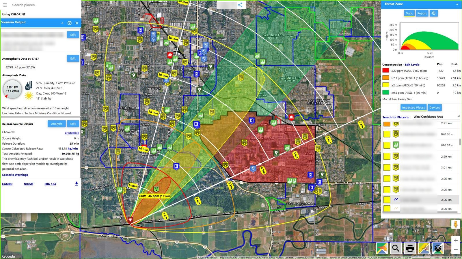
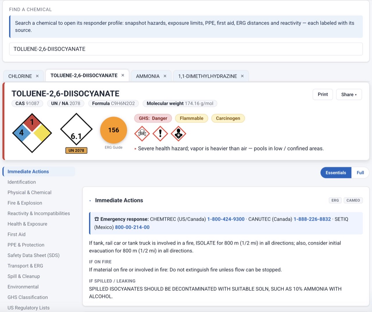
Search by UN number, placard, name or the patient's symptoms. The ERG 2024 isolation and protective-action distances draw on the map, turned to the live wind, before the first apparatus stops. The Chemical Profile puts NIOSH, CAMEO and DOT on one page with the source on every line.
The first decision
Shelter in place or evacuate. A school downwind, a hospital, a care home. Someone will ask you to justify it later. Right now you have to make it.
ALOHA and the Pro models draw up to four levels of concern with the census population inside each. Threat at a point gives the indoor and outdoor dose over the first hour for that school, so the call is a number, not a feeling. Wind-confidence lines show where the plume goes if the wind backs or veers.
Someone has to go in
The entry team suits up on your word. What the suit stops, how long the air lasts at this work rate, what the meter is really reading, how hot it is inside the suit: those are your responsibility before they are anyone else's.
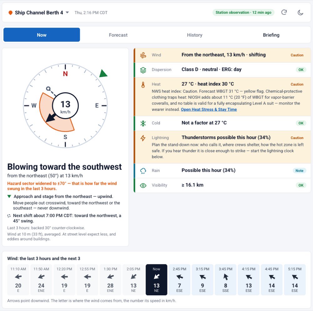
Suit breakthrough by chemical (ASTM F739), the respirator class and SCBA time (OSHA 1910.134), APR canister life, PID and LEL correction factors, heat stress and stay time. Incident Weather read as a size-up: approach sector, stability, the next wind shift, lightning and heat for the crews.
Everyone accounted for
Crews move, assignments change, the radio is busy and the tactical worksheet is a wet whiteboard. The one thing you cannot lose is where your people are.
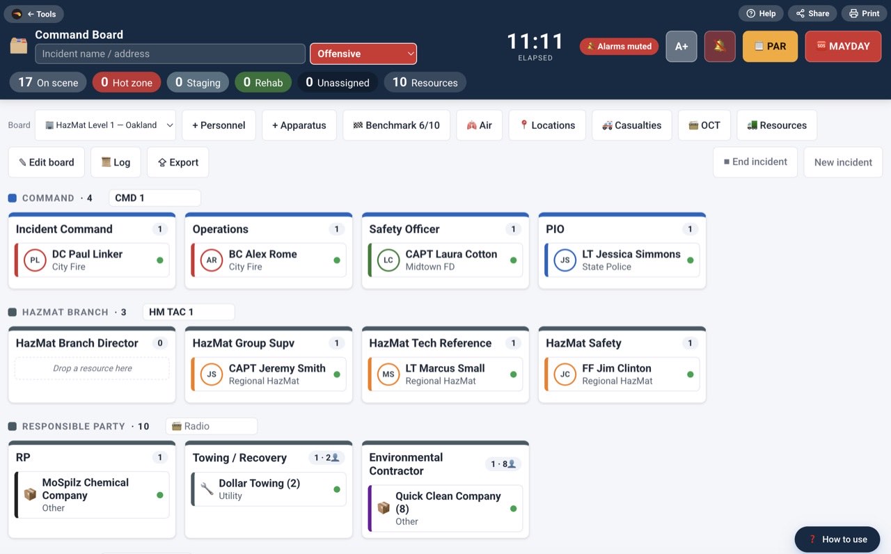
The Command Board takes crews onto assignments by drag and drop, with one-tap PAR, air and work-cycle timers, MAYDAY and an automatic ICS 214 log, and keeps working without a connection. My Status from the phone, the team status board, the roster with QR join, GPS shared only while responding.
The neighbors, the partners, the plant
Mutual aid arrives with its own map. The plant has readings you cannot see. Dispatch, the LEPC and the county want the same picture, now, and again by email.
Call-down notification by email and SMS with the plume link, from templates, with a delivery log. Share links that partners open without an account. A plant's detectors and met stations feed the same map, and a sensor-driven plume follows the readings as they report.
After, and between calls
The report is due, the review is coming, and the next call will not look like this one. The team that does well on it is the team that practiced.
PDF and Word reports with the map, zones and population; eight FEMA ICS forms, from the 201 briefing to the 214 activity log and the 233 action tracker; the incident record with tasks, log and costs. Story missions on a private exercise incident with the real tools, guided to learn and tested to qualify; Basics lessons on the tools and models, and incident-command lessons on taking command and accountability; a practice mode in most tool tours.
Specifications
- Dispersion models
- ALOHA 5.4 algorithms (US EPA and NOAA): Gaussian and heavy-gas dispersion; direct, puddle, tank and gas-pipe sources; RAILCAR 4 source term for pressurized-liquid tank cars (DHS Jack Rabbit tests). PRO liquid flow and pipe, stack and jet, elevated heavy gas, binary reaction, water-reactive spills, smoke and deposition, petroleum and crude products. SCICHEM complex terrain comes with Live Facility.
- Fire and explosion
- Pool fire, jet fire, BLEVE fireball and flash fire. PRO pool-fire radiation with smoke obscuration, vapor-cloud explosion (Baker-Strehlow-Tang), solid blast (Kingery-Bulmash), gas-cylinder burst, liquid-pipe jet fire, boilover (INERIS Omega-13), BESS battery fire with HF plume.
- Radiological
- PRO Nuclear detonation (Glasstone-Dolan) with WSEG-10 fallout; dirty bomb (HotSpot method); radiation, biodosimetry, ARS and countermeasure calculators.
- Guidance built in
- ERG 2024 tables for hazmat, IED, BLEVE, chemical-warfare agents and pipelines; NIOSH Pocket Guide; CAMEO Chemicals reactivity; CHEMM and REMM; FEMA ICS 201, 202, 203, 204, 208, 211, 214 and 233; NFPA 1584; DHS-ATF and NGIC standoff cards; UN SaferGuard explosives distances.
- Chemical library
- 1,300+ chemicals, solutions and mixtures including LPG, gasoline and crude assays; custom mixtures with key-component modeling; properties labeled with their source.
- Tools and calculators
- 80 in nine groups that follow the incident, from identify to reference. Search tolerates typos; a read-only share link for any result; a how-to tour on every tool, most with a practice mode; help in five languages.
- Weather
- Live conditions and forecasts from The Weather Company, nearest station first, with data-quality flags; your own met station; manual entry from the scene; automatic stability class and ERG day or night.
- Maps
- Google Maps or OpenStreetMap; satellite imagery, live traffic, Street View; KML/KMZ, WMS overlays and your own imagery; drawing and measurement; live feeds for weather radar, NWS alerts, air quality, wildfires, earthquakes, flood gauges, tsunami, power outages, boom sites, hydrants and AIS vessels.
- Personnel
- My Status from the phone; team status board with teams and officer overrides; PAR roll calls; roster with QR join and a phone-only Responder role; GPS only while responding; responder emergency alarm; Command Board accountability; incident chat with @mentions and push.
- Training
- Four story missions on a private exercise incident with the real tools: guided to learn, tested to qualify, with expiry; eleven Basics lessons on the workspace, chemicals, levels of concern, weather and running models; three incident-command lessons on taking command, the roster and the record, and accountability; the chief's Team tab with the matrix, curricula and assignments.
- Incident record
- Header, tasks, live activity log with responder, ICS role, time and tags; costs against published rate schedules with a cost review; ICS 202, 203, 204, 208 and 214 to Word or PDF; scenario history for every run.
- Reports, exports, imports
- PDF and Word reports with map imagery, zones, impacted places, infiltration analysis and population; KML/KMZ, Shapefile, CAP; weather briefing; public share links. Imports: Tier II, RMP, Seveso and E2 inventories, KML/KMZ drawings, predefined scenarios for pre-plans and drills.
- Runs on
- Any modern browser on Windows, macOS, Linux, iOS and Android, nothing to install; iOS and Android apps with background location for responder tracking; the Command Board and the coordinate converter work offline. English, French, Spanish, German and Chinese, including the help; metric or US units per user.
- Delivery and security
- Cloud service at ceres.vlahi.com, updated continuously, or a private deployment; email and phone support for licensed teams. Email and password with two-factor authentication, or Microsoft and Google accounts; brute-force protection; roles from responder to site administrator; share links limited to what you publish.
Products
Three products and the free version. Each product includes the one before it, licensed per site. No prices here: write to sales@vlahi.com for a quote. A hazmat team usually starts with HAZMAT Team.
CERES Free
ALOHA direct, puddle, tank and gas-pipe sources, the full ERG event set, the map, scenario history and the free tools.
Vulnerability and Risk
Adds the Pro models and calculators (fire, blast, boilover, battery, radiological), vulnerability zones, threat at a point for many receptors, population impact, predefined scenarios, RMP, E2 and Seveso support, advanced reports.
HAZMAT Team
Everything in Vulnerability and Risk, for the whole team on one shared site: detectors and met stations, live weather and traffic, Tier II, RMP, Seveso and E2 imports, sensor-driven plume and locate source, alerts, team tracking, offline mode, history.
Live Facility
Everything in HAZMAT Team, plus SCICHEM puff dispersion for wind shifts, calm winds and complex terrain, eight-hour runs, soot and deposition, wide-area transport, head counting, voice and SMS notification, continuous monitoring of your detectors and weather.
To the people who go toward it
CERES is built with fire departments, hazmat teams and plant fire brigades in North America, Europe and Asia, and shaped by what they asked for on scene. The measure of it was never the feature list. It is whether the zone was right, whether the crew came out, and whether the report told the truth. That part is your work, and it is the hardest work there is. Ours is to make sure nothing in the software stands between you and it.
Thank you for going toward it. Vlahi Systems